1/8


Distance - Draw to Measure
1K+ေဒါင္းလုဒ္မ်ား
16MBအရြယ္အစား
1.5.1(28-03-2025)နောက်ဆုံး ဗားရှင်း
အေသးစိတ္မ်ားျပန္လည္သံုးသပ္မႈမ်ားဗားရွင္းမ်ားအချက်အလက်
1/8
Distance - Draw to Measure ၏ ရွင္းလင္းခ်က္
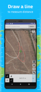
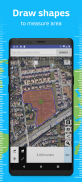
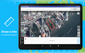
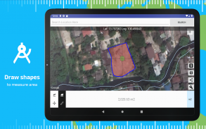
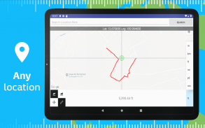
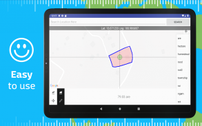
မြေပုံတလျှောက်အကွာအဝေးကိုတိုင်းတာရန်ဆွဲပါ၊ ဤအက်ပလီကေးရှင်းနှင့်လွယ်ကူသည်။ အခုareaရိယာတိုင်းတာခြင်းနှင့်အတူ။
အသုံးပြုမှု
-------
ရိုးရှင်းစွာတို့ထိခြင်းအားဖြင့်။ ၎င်း၏အကွာအဝေး / findရိယာကိုရှာရန်မြေပုံပေါ်တွင်လမ်းကြောင်းဆွဲပါ။
Move Move နှင့် Measure mode အကြားပြောင်းပါ။ ထို့ကြောင့်သင်တိုင်းတာခြင်းစတင်ရန်သို့မဟုတ်ချက်ခြင်းစတင်လိုသည့်နေရာကိုသင်ရွေးချယ်နိုင်သည်။ မြေပုံကို ဆက်၍ ဆက်လက်အကွာအဝေးကိုတိုင်းတာနိုင်သည်။
Area Areaရိယာနှင့်အကွာအဝေးတွက်ချက်မှုအကြားပြောင်းပါ။
display Display ယူနစ်ကိုပြောင်းရန် "ယူနစ်" ခလုတ်ကိုနှိပ်ပါ။
over စတင်ရန် "ဖျက်ရန်" ခလုတ်ကိုနှိပ်ပါ
export ရလဒ်ကိုတင်ပို့ရန်“ Share” ခလုတ်ကိုနှိပ်ပါ
မွတ္စု: အကွာအဝေးနှင့်Areaရိယာသည်ကမ္ဘာ၏အဖြစ်များသည့်အကိန်းအရတွက်ချက်သည်။
Distance - Draw to Measure - ဗားရွင္း 1.5.1
(28-03-2025)ဘာအသစ္ရွိလဲUpdate framework versions
Distance - Draw to Measure - APK သတင္းအခ်က္အလက္
APK ဗားရွင္း: 1.5.1package: com.myice92.distanceအမည္: Distance - Draw to Measureအရြယ္အစား: 16 MBေဒါင္းလုဒ္မ်ား: 16ဗားရွင္း : 1.5.1ျဖန္႔ခ်ိသည့္ ရက္စြဲ: 2025-03-28 21:35:19စခရင္အေသး: SMALLအေထာက္အပံ့ေပးနိုင္ေသာ စီပီယူ:
ပက္ေက့ဂ်္အိုင္ဒီ: com.myice92.distanceSHA1 လက္မွတ္: B2:A9:87:95:84:5A:68:2D:BE:CE:44:EB:6C:01:44:AF:99:21:87:64ထုတ္လုပ္သူ (CN): Androidအဖြဲ႕အစည္း (O): Google Inc.ေဒသဆိုင္ရာ (L): Mountain Viewနိုင္ငံ (C): USျပည္နယ္/ၿမိဳ႕ေတာ္ (ST): Californiaပက္ေက့ဂ်္အိုင္ဒီ: com.myice92.distanceSHA1 လက္မွတ္: B2:A9:87:95:84:5A:68:2D:BE:CE:44:EB:6C:01:44:AF:99:21:87:64ထုတ္လုပ္သူ (CN): Androidအဖြဲ႕အစည္း (O): Google Inc.ေဒသဆိုင္ရာ (L): Mountain Viewနိုင္ငံ (C): USျပည္နယ္/ၿမိဳ႕ေတာ္ (ST): California
Distance - Draw to Measure ၏ ေနာက္ဆုံးဗားရွင္း
1.5.1
28/3/202516 ေဒါင္းလုဒ္မ်ား14.5 MB အရြယ္အစား
အျခား ဗားရွင္းမ်ား
1.5.0
8/3/202516 ေဒါင္းလုဒ္မ်ား14 MB အရြယ္အစား
1.4.11
24/2/202516 ေဒါင္းလုဒ္မ်ား16.5 MB အရြယ္အစား
1.4.10
1/2/202516 ေဒါင္းလုဒ္မ်ား8.5 MB အရြယ္အစား
1.4.8
19/11/202416 ေဒါင္းလုဒ္မ်ား17 MB အရြယ္အစား
1.3.11
24/9/202316 ေဒါင္းလုဒ္မ်ား6 MB အရြယ္အစား
1.2.0
13/9/202016 ေဒါင္းလုဒ္မ်ား7.5 MB အရြယ္အစား


Poket Contest 4.11
4.11
4.11

Pokeland Legends3.88
3.88


က႑တူအက္ပ္မ်ား

သင္ႏွစ္သက္ႏိုင္သည္မ်ားမွာ...

English


